*** OFF THE MARKET ***
Alpine 85 Acres
Apache County, Arizona
Pictures
Please
click on any of the pictures for a larger view
|
|
|
|
|
[1]
|
[2]
|
[3]
|
|
|
|
|
|
[4]
|
[5]
|
[6]
|
|
|
|
[7] |
[8] |
[9] |
|
|
|
[10] |
[11] |
[12] |
|
|
- |
[13] |
[14] |
- |
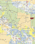
Location, Access
& Maps
Please click on any of the maps
for a larger view
|
|
|
|
|
|
General
location in Arizona |
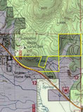
Neighborhood
map |
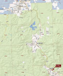
Topographic
Map |
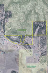
Aerial
Image |
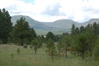
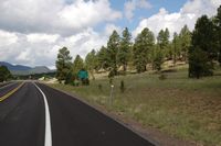
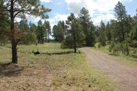
The property is located directly adjacent to the town of Alpine in northeastern Arizona at the base of Escudilla Mountain which is Arizona’s third highest mountain being over 10,900 feet in elevation. Alpine is located approximately 27 miles south of Springerville/Eagar. Access is provided by US Highway 180 to the town of Alpine and approximately a half mile east of the intersection of US 180 and US 191. The Alpine Admin Site of the Forest Service is just of the northwest edge of the property. The property includes over a quarter mile of paved frontage along US Highway 180. Interior access is provided by private dirt roads.
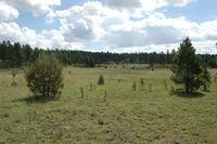
Property Description
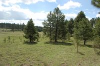
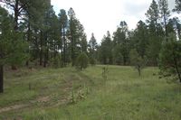
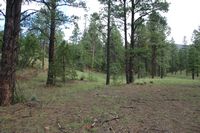
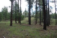
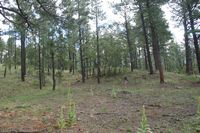
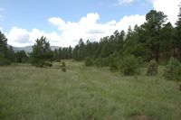
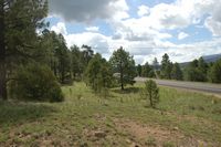
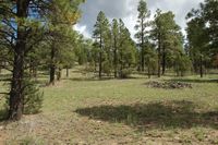
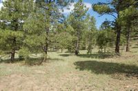
One of the finest properties in Alpine because of its beauty and location near town while offering complete privacy. The property is sandwiched between the Bush Valley and Escudilla Mountain, lies at 8,000 feet elevation and includes 85 deeded acres. With tremendous views overlooking the Bush Valley, San Francisco River and surrounding mountain tops the property backs up to national forest and includes paved access from US Highway 180. The property lies in two contiguous parcels with the entire north boundary being along the national forest. The front parcel includes approximately 45 acres and over a quarter mile of paved frontage along the highway. The 45 acres is roughly rectangular in shape with the western boundary coming to a point along the highway. Topography is generally sloping from north to south towards the highway with an open meadow located on the eastern edge. This area includes an earthen tank designed to catch run-off for livestock water. There is also a small spring near the center of the property which provides a small area of sub-irrigated meadow. The second parcel includes 40 acres and is located to the northeast of the first parcel and is connected by a property corner and road easement. The 40 acres is square in shape and is surrounded by national forest on the west, north and east boundaries. Topography on the 40 acres includes hillside dropping off to an open meadow reaching through the center of the property. Both parcels include some open meadow but have large stands of ponderosa pine and live oak trees. The extensive tree cover provides privacy and numerous building sites. The trees have been thinned and managed for wildfire protection within the past five years. Vegetation consists of ponderosa pine forest and alpine meadow grasses.
Land Tenure
85 acres deeded, property could be split into a 40 acre and a 45 acre parcel upon sale.
Water
Domestic water is available from the Alpine Domestic Water Improvement District. There is a 6” water main line crossing the property and a 1 ½” branch serving cabins on adjacent properties. There are no existing hook-ups in use on the subject.
Utilities
Telephone and electrical service is available in the immediate area although not in use on the subject property. Navopache Electrical Cooperative is the electrical service provider and Frontier Communications provides telephone service. Sewer service is available from the Alpine Sanitary District. There are no existing hook-ups in use on the property however, there is a main sewer line near the western edge of the property. Service could be provided by a septic and pressure pump system for the effluent.
Zoning
Apache County - General Agricultural, this is the basic general rural zoning designation.
Deed Restrictions
The property will transfer upon sale subject to a Declaration of Restrictions which will limit potential uses of the property to a one acre minimum lot size, site-built homes, construction setbacks, signage/lighting and various other restrictions. A detailed copy of the restrictions will be provided.
Legal Description
Township 5 North Range 30 East
Gila and Salt River Baseline & Meridian
Section 12: portion thereof – lengthy legal
Assessor Parcels
Apache County #101-18-001(split) 2016 property taxes = $126.40
Apache County #101-18-001B 2016 property taxes = $74.68
Remarks
Alpine is an authentic small western mountain town, a quiet getaway with spectacular scenery with easy driving distance to many fishing lakes and streams. Luna Lake is a short two mile drive. The area is also located on the boundary between the famous hunting Units 1 & 27 known for large herds of elk and world-class 400+ point bulls. With the large ponderosa pine and beautiful oak trees scattering the property and the magnificent views of Escudilla Mountain, Bush Valley and the San Francisco River, this property has great potential for a private, secluded home-site in the pines or possibly development into smaller tracts. The two parcels could be sold separately, all offers will be considered.
Price
$1,200,000 – Cash