§ Return
to all of our listings
*** OFF THE MARKET ***
1,921± Acre Farm
Including 273.74± acres of Pecan Plantings
Bowie Area, Cochise County, Arizona
Pictures
Please click
on any of the pictures for a larger view
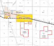
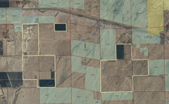
Location
& Maps
Please click on any of the maps
for a larger view
Location/Access
Located South of I-10 at Bowie, in Cochise County, Arizona.
Located on the east side of Apache Pass Road, on the north side of the Rodeo Road
alignment.
Frontage
Physical access is via Apache Pass Road to Rodeo Road, thence east on Rodeo Road
1.1 miles east to the property. Apache Pass is a two lane paved roadway, Rodeo
Road is a dirt roadway.
Zoning/Use
RU-4-Rural 4 acre minimum/Irrigated Field Crops/Pecans/Fallow/Desert.
Water Right Acres
Located outside of all existing AMA’s and INA’s. No local irrigation districts.
Acreages: Pecans: 273.74± acres, varying from 1978 to 2010 plantings;
Fallow/Desert: 1,627.48± acres;
Building sites: 20.00± acres;
Total 1,921.22±
Water Source
Fourteen registered. Wells 2, 3, 4 and 5 are fully equipped and operable with electric
motors and turbine pumps.
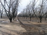
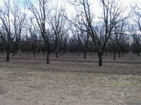
Pecan Plantings
75.09± acres of Western Schley (80%) and Wichita (20%) varieties, planted in 1979
on a 20’ x 40’ spacing and irrigated with solid set sprinklers;
20.00± acres of Western Schley (80%) and Wichita (20%) varieties, planted in 1998
on a 22.5’ x 40’ spacing and irrigated with solid set sprinklers;
55± acres of Western Schley (80%) and Wichita (20%) varieties, planted in 1978 to
1980 on a 30’ x 30’ spacing and irrigated with solid set sprinklers;
74.52± acres of Western Schley (80%), Mohawk (5%) and Wichita (15%) varieties,
planted in 1979 on a 20’ x 40’ spacing and irrigated with micro sprinklers;
38± acres of Western Schley (80%) and Wichita (20%) varieties, planted in 2000 and
2005 on a 22.5’ x 40’ spacing and irrigated with solid set sprinklers;
11.13± acres of Western Schley (80%) and Wichita (20%) varieties, currently being
planted in 2010on a 32’ x 32’ spacing and irrigated with Nelson rotators.
Flood Zone
Zone A – 15± acres, balance is Zone X.
Elevation
3,690 to 3,800± feet.
Equipment
See the attached equipment list. The equipment is included in the purchase price.
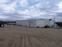
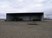
Buildings
Building #1 (West): 60’ x 75’ equipment shed, 60’ x 50’ nut cold storage room with
refrigeration, 25’ x 30’ parts room, metal construction, concrete floor.
Building #2 (Wade): 50’ x 50’ equipment shed, 60’ x 50’, metal construction,
concrete floor.
Building #3 (Northeast): 55’ x 75’ equipment shed, metal construction, concrete
floor.
Building #4 (Southeast): Old military Sstyle Quonset, metal rib over concrete.
Utilities
Electric: Sulphur Springs Valley Electric Coop.
Natural Gas: Southwest Gas.
Telephone/Internet: Valley Telecom Group.
Water: Domestic and Irrigation Wells.
Sewer: Septic.
USDA/FSA Data: Tracts #: 754, 758, 759 and 2048 Cropland Acres: 1,491.5
Crop Base Acreage Direct Yield
Oats 15.3 6 bu.
Upland Cotton 895 850#
Price
$5,250,000 or $2,735 per gross acre.
Terms
Cash.
Printable
Brochure
 Please click here to download (about 1mb)
a printable brochure in Adobe Acrobat format. If you get frustrated
trying to make this work on your computer, don't hesitate to ask us
to mail you a printed and bound brochure instead.
Please click here to download (about 1mb)
a printable brochure in Adobe Acrobat format. If you get frustrated
trying to make this work on your computer, don't hesitate to ask us
to mail you a printed and bound brochure instead.