*** OFF THE MARKET ***
Concho Ranch
Apache County, Arizona
Pictures
Please
click on any of the pictures for a larger view
|
|
|
|
|
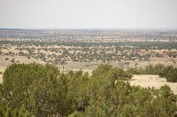
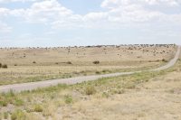
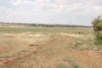
[1] Overview looking north across the eastern half of the ranch |
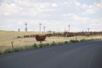
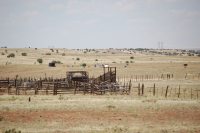
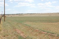
[2] Shipping corrals along Highway 180A |
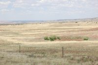
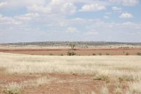
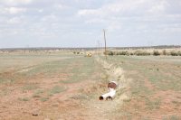
[3] Dirt tank and typical range land along Highway 180A |
|
|
|
|
|
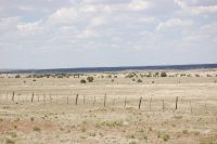
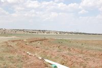
[4] Typical range land |
[5] Highway 5020, ranch lies on both sides |
[6] Shipping corrals at the farm |
|
|
|
|
|
[7] One of the irrigation storage reservoirs |
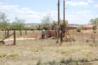
[8] Irrigation well with electrical pole |
[9] Fallow farmland |
|
|
|
|
|
[10] Fallow farmland |
[11] Fallow farmland |
[12] Fallow farmland |
Location
& Maps
Please click on any of the maps
for a larger view
|
|
|
|
|
|
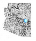
General
location in Arizona |
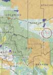
Location
map |
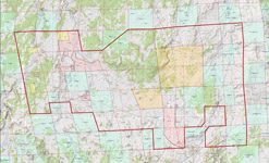
Topo
Map |
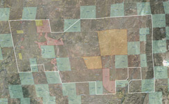
Aerial
map
|
The ranch is located in west central Apache County approximately 18 miles east of Snowflake, 30 miles east of Show Low and 15 miles west of St. Johns, Arizona and immediately north of the small community of Concho. State Highway 180A and County Highway 5020 run through the ranch from west to east and north to south providing paved access throughout. The majority of the deeded land is contained in two primary blocks. Approximately 830 acres is located at the intersection of highway 180A and 5020 and includes over two miles of paved frontage directly north of Concho. The second block is located in Mail Station Draw, one mile north of highway 5020 and contains over 1,200 acres. The remaining deeded parcels are located throughout the ranch containing livestock waters (windmills or dirt tanks). There are numerous county, private and ranch roads providing vehicle access throughout the ranch.
Land Tenure
Tenure |
Acres |
| Deeded |
2,105 |
| State |
4,721 |
| BLM |
320 |
| Private lease (SRP) |
3,200 |
| Private lease (First United) |
16,175 |
| Open range grazing (subdivision surface grazing) |
4,950 |
| Total (49 sections) |
31,471 |
Legal Description
The ranch is located in Township 13 North Range 25 & 26 East, Gila and Salt River Baseline and Meridian with the deeded parcels scattered throughout the ranch located at the primary watering locations. The state lease lands are contained primarily in a checker-board pattern with the private lease and open range, subdivision grazing lands.
Apache County Assessor parcel numbers, taxes and acreage:
APN |
Acres |
Full Cash Value |
2007 Taxes |
| 212-02-002B |
531.17 |
$8,591.00 |
$392.86 |
| 212-02-006 |
734.00 |
$4,698.00 |
$44.52 |
| 212-03-003C |
830.94 |
$5,318.00 |
$50.40 |
| 212-03-003D |
6.60 |
$43.00 |
$0.44 |
| 212-62-001 |
2.30 |
$15.00 |
$0.12 |
| Total |
2,105.01 |
$18,665.00 |
$488.34 |
Carrying Capacity
Tenure |
AUs |
| Deeded* |
23.0 |
| State |
50.5 |
| BLM |
3.5 |
| Private lease (SRP) |
35.0 |
| Private lease (First United) |
177.0 |
| Open range grazing* |
50.0 |
| Total yearlong |
343.0 |
*deeded and open range grazing capacities are based on the State recommended stocking rate of 7 head per section.
Grazing Fees
State Lease fee is $2.40 per animal unit month, BLM fee is $1.35 per animal unit month.
Property Description
The ranch is contained in one primary block being 6 miles from north to south and 11 miles from east to west at the widest points. The ranch is more or less rectangle with State Highway 180A crossing through the central portion from north to south and County Highway 5020 crossing through the southern edge of the ranch from east to west. Range improvements are typical with perimeter fencing and interior cross-fencing. There are no headquarter building improvements on the ranch, only shipping corrals and holding traps.
The large block of deeded land located along Highway 180A contains a typical set of livestock shipping corrals and several dirt tanks for livestock water. The current owner has an agreement with the Concho sewer company to utilize effluent water for potentially irrigating 300 acres of pastureland. Historically the pasture has not been irrigated, but could possibly be put into production in the future.
The second deeded block located in Mail Station Draw includes nearly 100 acres of fallow farm land. The farm has historically been irrigated with water claims including 1,248 acre feet per annum storage rights located in three separate reservoirs, 300 acre feet per annum underground sub-flow and an irrigation well capable of producing 800 gallons per minute. The irrigation well equipment is in place, but has not been used for several years, operating condition is unknown, the well is powered by electricity. The farm is irrigated by head gates and dirt ditches. Amount of available water depends heavily on the annual rainfall and varies significantly from year to year.
Elevation ranges from 5,500' in Mail Station Draw near the north boundary to 6,000' near the south eastern boundary near State Highway 61.
Vegetation is Plains & Desert Grassland with Pinion/Juniper woodlands intermixed. Rainfall averages 17.2" per year at Show Low and 11.2” per year at St. Johns.
Area Description
The ranch is located in eastern Arizona on the north facing slope of the Mogollon Rim 30 miles northeast of the Show Low/Pinetop area and just north of the Apache-Sitgreaves National Forest containing the White Mountains of Arizona. The Show Low area and the Apache-Sitgreaves National Forest is known for its many large ponderosa pines, large herds of elk and close proximity to numerous streams and lakes for trout fishing. The mountains are popular for many outdoor activities such as hiking, hunting, biking and camping. Also nearby is the Sunrise Ski Area on the White Mountain Apache Indian Reservation located less than an hours drive to the south. Sunrise has three downhill ski mountains with trails for all levels of experience. Honda Resort and Casino is also located on the Apache Indian Reservation just outside Pinetop approximately a 30 minute drive from the ranch. Honda Resort and Casino has a full casino, resort hotel, dining, entertainment and conference center.
Water
Livestock water is provided by 12 wells and 39 registered water claims being mostly dirt tanks catching rain run-off waters.
Note: The water filings are shown on the topo and aerial maps above.
Soils
- Rudd association: Well drained, shallow and very shallow, undulating gravelly loams and very stony loams formed in residuum from basalt.
- Moenkopie-Sandstone rock land association: Well-drained, shallow and very shallow, nearly level to moderately sloping loamy sands formed in residuum from sandstone, and sandstone rock outcrops.
- Tours-Jocity association: Well-drained, deep, nearly level to gently sloping clay loams and sandy clay loams formed in alluvium.
Utilities
Telephone is provided by Frontier Communications, electricity is provided by Navopache Electric Cooperative. Telephone and electricity are available throughout the ranch.
Flood Zone
Zone C, areas of minimal flood hazard except natural drainage areas which are Zone A, areas of 100-year flood hazard.
Price
$1,500,000 – Cash
Printable
Brochure
 Please click here to download (about 3.4MB) a printable brochure in Adobe Acrobat format. If you get frustrated
trying to make this work on your computer, don't hesitate to ask us
to mail you a printed and bound brochure instead
Please click here to download (about 3.4MB) a printable brochure in Adobe Acrobat format. If you get frustrated
trying to make this work on your computer, don't hesitate to ask us
to mail you a printed and bound brochure instead
Contact
Offered
for sale exclusively by:
Traegen H. Knight
Headquarters West, Ltd.
PO BOX 1980
St. Johns, AZ 85936
Phone: (928) 524-3740, Fax: (928) 563-7004, Cell: (602) 228-3494
Email: info@headquarterswest.com
Web: www.headquarterswest.com/concho
See
Also
Also handled
by Traegen Knight in the area:
- Sold - Chilcott Ranch - 44,274 acres in Navajo County
- Sold -
Goodwater Ranch
- 56,158 acres in Navajo County
- Sold - Greens
Peak Ranch
- 17,938 acres Apache County
Handled
by Con Englehorn:
- Sold
- Chevelon Canyon, 66,370 acres/728
AU in Navajo County
Disclaimer:
This information was obtained from sources deemed to be reliable but
is not guaranteed by the Broker. Prospective buyers should check all
the facts to their satisfaction. The property is subject to prior
sale, price change, or withdrawal.
Keywords - real
estate , land , property 85290 85925 85932 85927 85938 85940 85924
85936 86509 86502 near n s e w north south east west springerville
witch well concho floy eagar nutrioso alpine beaverhead