*** SOLD ***
84.18 acres of mixed use land
Camp Verde I-17 & SR 260 Property
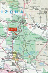
Yavapai County, Arizona
Pictures
Please
click on any of the pictures for a larger view
|
|
 |
[1] |
[2] |
[3] |
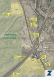
Location
and Maps
Location
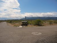
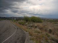
Located at the southeast corner of I-17 & SR 260. The property has ¼ mile frontage on I-17.
Size
84.18 surveyed acres (tax roll acreage is 84.03 acres).
Zoning
About 10 acres Town of Camp Verde C2, the balance is R1L-70, the entire property is noted as commercial land use in the general plan land use map.
Utilities
All utilities are available including Camp Verde water and sewer.
Taxes
2016 taxes and assessments were $48,289. Most of the current tax bill is attributable to a sewer assessment with 2016 being the 10th of the 20 year assessment for parcels 403-22-035H and -035A.
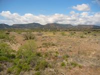
Description
This is a great opportunity with the property being in the most strategic location for commercial development in north central Arizona on the I-17 corridor between Phoenix and Flagstaff. Most of this land is level usable land, flood maps do not show any flood hazards but there is a small wash bisecting it. There are multiple access points to the property from established ADOT ingress/egress points on 260, including a right of way from the southern end across State Trust land that connects to the lighted intersection of SR 260 and Finnie Flat Road.
Price
$2,104,500 cash
Printable Brochure
 Please click here to download (about 800kb)
a printable brochure in Adobe Acrobat format. If you get frustrated
trying to make this work on your computer, don't hesitate to ask us
to mail you a printed and bound brochure instead.
Please click here to download (about 800kb)
a printable brochure in Adobe Acrobat format. If you get frustrated
trying to make this work on your computer, don't hesitate to ask us
to mail you a printed and bound brochure instead.