***
SOLD ***
Note:
We've also listed a 49 Acre parcel
about a mile to the west and 9
and 10 acre parcels
in Arlington
9.43± Acres
Northeast Corner
Lower Buckeye and Airport Road
Maricopa County, Arizona
Pictures
Please click on any of the pictures
for a larger view
|
|
|
|
|
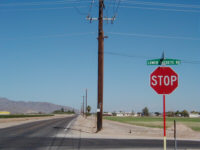
[1]
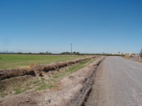
SW corner looking N
|
[2]
SW Corner looking E
|
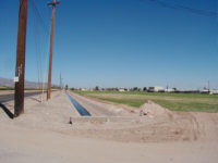
[3]
SW Corner looking N
|
|
|
|
|
|
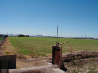
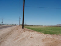
[4]
NE Corner looking S
|
[5]
NE corner looking W
|
[6]
SE corner looking W
|
Quick Info
| Location |
Northeast
Corner Paved Airport & Paved Lower Buckeye |
| Size |
9.43±
Assessor Acres |
| Access |
350'
paved Lower Buckeye, 1192' paved Airport, 345' gravel Watkins |
| Current
Zoning |
Maricopa
- R 43 |
| General
Plan |
Town
of Buckeye - Rural Residential |
| Flood
Hazard |
100%
Zone X - Outside of the 100-year flood plain |
| Utilities |
Arizona
Public Service, Septic, White Citrus Water Company Service Area |
| Water |
Roosevelt
Irrigation District |
| Easements |
Roadway,
electric, telephone typical. RID Lateral on west border. |
| Improvements |
Irrigation
ditch, irrigation leveling, no buildings |
| Taxes |
Year
2004 - $305.00 |
| Comments |
Property
has commercial investment and residential development potential,
currently irrigated bermuda. |
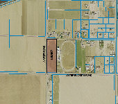
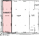
Location & Maps
Please click on any of the maps
for a larger view
|
|
|
|
|
|
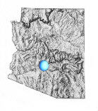
General
location in Arizona
|
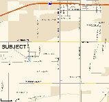
Location
Map
|
Aerial
Photo
|
Platt
Map
|
The
9.43± acres are located on the northeast corner of Lower Buckeye
Road and Airport Road, approximately 2 miles south of the Verrado
and I-10 Interchange. The property lies within 2-6 miles of the Verrado
and Sundance Residential Communities that are in the Town of Buckeye.
Access
and Frontage
The property has
approximately 350' of paved access from Lower Buckeye Road on the
south border, and approximately 1192' of paved frontage from paved
Airport Road on the west border. Current access to Interstate 10 from
the property is ¾ mile north on Airport, 1.5 miles east on
Yuma, 2 miles north on Jackrabbit to I-10. The property is located
2.5 miles south of the Verrado and Interstate 10 interchange, which
is planned to continue south, connecting Airport to Interstate 10.
Description
The offered property
includes 9.43± tax roll acres of land. The land is located
in Maricopa County and zoned R-43. Current use of property is irrigated
field crop, located in the Roosevelt Irrigation District. Current
surrounding land uses within 1 mile include rural residential to the
north, south, east and west and irrigated field crop to the west and
south. Land uses within 2 miles include a mix of cropland, planned
community development, planned residential and rural residential.
Printable
Brochure
 Please click here to download (about 900kb)
a printable brochure in Adobe Acrobat format. If you get frustrated
trying to make this work on your computer, don't hesitate to ask us
to mail you a printed and bound brochure instead.
Please click here to download (about 900kb)
a printable brochure in Adobe Acrobat format. If you get frustrated
trying to make this work on your computer, don't hesitate to ask us
to mail you a printed and bound brochure instead.
Contact
Offered for
sale exclusively by:
Headquarters West,
Ltd.
Shawn T. Wood, Agent representing
family members
810 N 2nd Street
Phoenix, AZ 85004-2016
Tel: 602-258-1647, Fax: 602-340-0927, Cell: 602-290-7516
Email: info@headquarterswest.com
Web: www.headquarterswest.com
See
Also
 49.82
acres about a mile to west, also being handled by Shawn Wood
49.82
acres about a mile to west, also being handled by Shawn Wood
9
and 10 acre parcels in
Arlington
Disclaimer: This information was obtained
from sources deemed to be reliable but is not guaranteed by the Broker.
Prospective buyers should check all the facts to their satisfaction.
The property is subject to prior sale, price change, or withdrawal.